Skip to content
Planning and GIS

Planning and GIS

Menu
  • Projects
    • Greenprint – Project Gallery
    • Climate-Smart Cities – Project Gallery
    • 10-Minute Walk – Project Gallery
    • Large-Landscapes – Project Gallery
    • Decision Support Tools – Project Gallery
    • Story Maps – Project Gallery
    • Trail Planning – Project Gallery
    • Organizational Databases Gallery
    • Community Futures – Project Gallery
  • Contact

Climate-Smart Cities – Project Gallery


Climate Smart Cities™ Dallas
Climate Smart Cities™ Philadelphia
Climate Smart Cities™ Denver
The Trust for Public Land is working with city staff, public agencies, and community organizations to help Richmond implement climate mitigation policies by prioritizing projects and generating climate-related funding.
Climate-Smart Cities Richmond
Together with municipal and community partners from six Rhode Island cities (Providence, Central Falls, Pawtucket, East Providence, Cranston, and Warwick), we’re bringing cutting-edge science, Geographic Information Systems (GIS) planning, and innovative design to prepare the entire region for a climate-resilient future with a particular emphasis on investments for underserved populations and integrated water management solutions.
Climate-Smart Cities Providence
With a grant from the Environmental Protection Agency (EPA), through the National Oceanic and Atmospheric Administration (NOAA), The Trust for Public Land’s national Climate-Smart Cities program is partnering with the City of Cleveland in providing key planning and decision-making support to help the city achieve regional resiliency goals by leveraging the power of green infrastructure for a healthy Great Lakes region and for those who need it most.
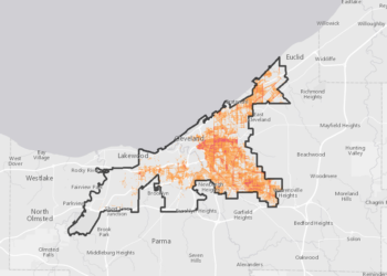
Climate-Smart Cities Cleveland
The Trust for Public Land’s national Climate-Smart Cities™ program is providing key planning and decision-making support to help the city achieve the goals laid out by the City of Nashville. Together with city and community partners, we’re bringing cutting-edge science, Geographic Information Systems (GIS) planning, and innovative design to prepare the entire region for a climate-resilient future with a particular emphasis on underserved populations and critical at-risk infrastructure.
Climate-Smart Cities Nashville
Our Climate-Smart Cities™ process bring together a team of experts to research, design, and build the infrastructure and tools that help increase our resilience to climate change.
Climate-Smart Cities – New Orleans
Our Climate-Smart Cities™ process bring together a team of experts to research, design, and build the infrastructure and tools that help increase our resilience to climate change.
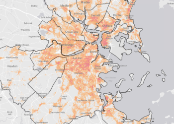
Climate-Smart Cities™ Boston Metro Mayors Region
Through our Climate Smart Cities Program at The Trust For Public Land we help cities strategically use parks and natural lands as "green infrastructure."
Climate-Smart Cities – Los Angeles
The City of Boston is tackling the challenges associated with climate change head on. In a city where a densely populated highly urbanized meets the sea, the city is doing the hard work to prepare for sea level rise, increasing urban temperatures, greater precipitation, and other risks through their robust and comprehensive climate analysis and action plan, Climate Ready Boston.
Climate-Smart Cities – Boston
The purpose of this study was to investigate what role NYC coastal green infrastructure (GI) played in building damages during Sandy. Specifically, the researchers wished to determine whether damages can be adequately predicted using only discrete physical relationships, such as topographic, distance to the coast, or proximity to a green space.
Climate-Smart Cities – New York City
The Planning for a Healthy, Connected Chattanooga initiative uses Geographic Information Systems (GIS) to develop a detailed strategy to take this work to the "next level," demonstrating how strategic green space planning contributes to a resilient Chattanooga.
Healthy Connected Chattanooga
This map highlights Urban Heat Island Hotspots, with elevated daytime land surface temperatures averaging at least 1.25 degrees Fahrenheit above the mean daily temperature during July and August of 2013.
Urban Heat Risk App
Green Infrastructure Analysis for city of Camden, New Jersey
Camden Green Infrastructure Analysis

Search for a project

Explore Project Galleries

  • Home
  • Greenprint
  • Climate-Smart Cities
  • 10-Minute Walk
  • Large-Landscapes
  • Decision Support Tools
  • Trail Planning
  • Story Maps
  • Community Futures
Copyright © 2019 - Planning and GIS